(ↄ) | Dror Bar-Natan: Album: About    Recent Changes    Random

<<  2020.07.04_Bruce_Hike_1-_Niagara_to_Welland  >>  
Jump to: Mathematica Notebooks | Links | Images | Other Files

With Assaf and Itai Bar-Natan.

The plan was to wake up early, drive from Toronto with 3 bikes, leave them at the end point, drive to the beginning point, hike back to the end point, bike back to the beginning point, and drive home.

We more or less did just that, but almost everything that could go wrong went wrong. We had a flat tire while prepping the bikes in the morning. It turned out we could only fit two bikes on the rack we had. I lost the bike keys in an embarrassing way, found them again in an even more embarrassing way, and that whole affair cost us about an hour. Then I left the lights on and we had to ask other people to help us jump-start the car (that, actually, was incredibly smooth and fast).

And it turned out that a 20km hike was very hard. I always had pain in my feet when hiking (that's why I bike so much more), and after months of biking a lot but barely walking, the pains were pretty terrible.

The ride back, only 13km and just Assaf and me (because of the bike we couldn't load) was oh so easy after that!

But it was fun overall, and nothing beats a day with the kids!

<< Shortcuts >>  
2020.07.18_Bruce_Hike_2-_Glendale_Bridge_to_Lake_Moodie  

<< Mathematica Notebooks >>

 Notebook (.pdf)Source (.nb)CreatedLast ModifiedSummary
1 index source 2024-03-17 10:30:27 2020-07-04 20:12:29  

<< Links >>

  1. Studied 2020-07-04 19:46:31: Biking_Path.

<< Images >>

previous full screen next


20200704_101357_HDR.jpg
Southern Terminus of the Bruce Trail.

20200704_102759_HDR.jpg

20200704_111315.jpg
A monument to General Brock.

20200704_111351_HDR.jpg
The Niagara River.

20200704_112344.jpg

20200704_113932.jpg

20200704_113954.jpg

20200704_114013.jpg

20200704_120043.jpg

20200704_134930.jpg

20200704_144207_HDR.jpg

20200704_144232.jpg

20200704_145436.jpg

20200704_150907.jpg

20200704_163406.mp4
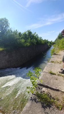
Spillway for the Welland Canal.

20200704_163443.jpg
Spillway for the Welland Canal.

20200704_163922.jpg
Spillway for the Welland Canal.

20200704_164059_HDR.jpg
Spillway for the Welland Canal.

Approximate_Hiking_Path.png
Hiking: from the right-most P to the left-most P.

Biking_Path.png

<< Other Files >>

PathInTimeline.gpx  


   <<  2020.07.04_Bruce_Hike_1-_Niagara_to_Welland  >>

All 3 Subfolders

nb   previews   thumbs  

All 26 Files

20200704_101357_HDR.jpg   20200704_102759_HDR.jpg   20200704_111315.jpg   20200704_111351_HDR.jpg   20200704_112344.jpg   20200704_113932.jpg   20200704_113954.jpg   20200704_114013.jpg   20200704_120043.jpg   20200704_134930.jpg   20200704_144207_HDR.jpg   20200704_144232.jpg   20200704_145436.jpg   20200704_150907.jpg   20200704_163406.mp4   20200704_163443.jpg   20200704_163922.jpg   20200704_164059_HDR.jpg   2020.07.18_Bruce_Hike_2-_Glendale_Bridge_to_Lake_Moodie - Shortcut.lnk   Approximate_Hiking_Path.png   Biking_Path.png   Biking_Path.url   index.html   index.m   index.nb   PathInTimeline.gpx